In southwest Salt Lake County, Utah, the creeks and washes flowing from the Oquirrh Mountains appear dry for much of the year. While they often go unnoticed, these channels collect stormwater, help recharge groundwater, and support the health of the shrinking Great Salt Lake. Recognizing both their importance and their vulnerability, the H2Oquirrh Vision Plan began with a clear purpose, to help communities recognize the value of these systems and plan for their future before development places them at risk.
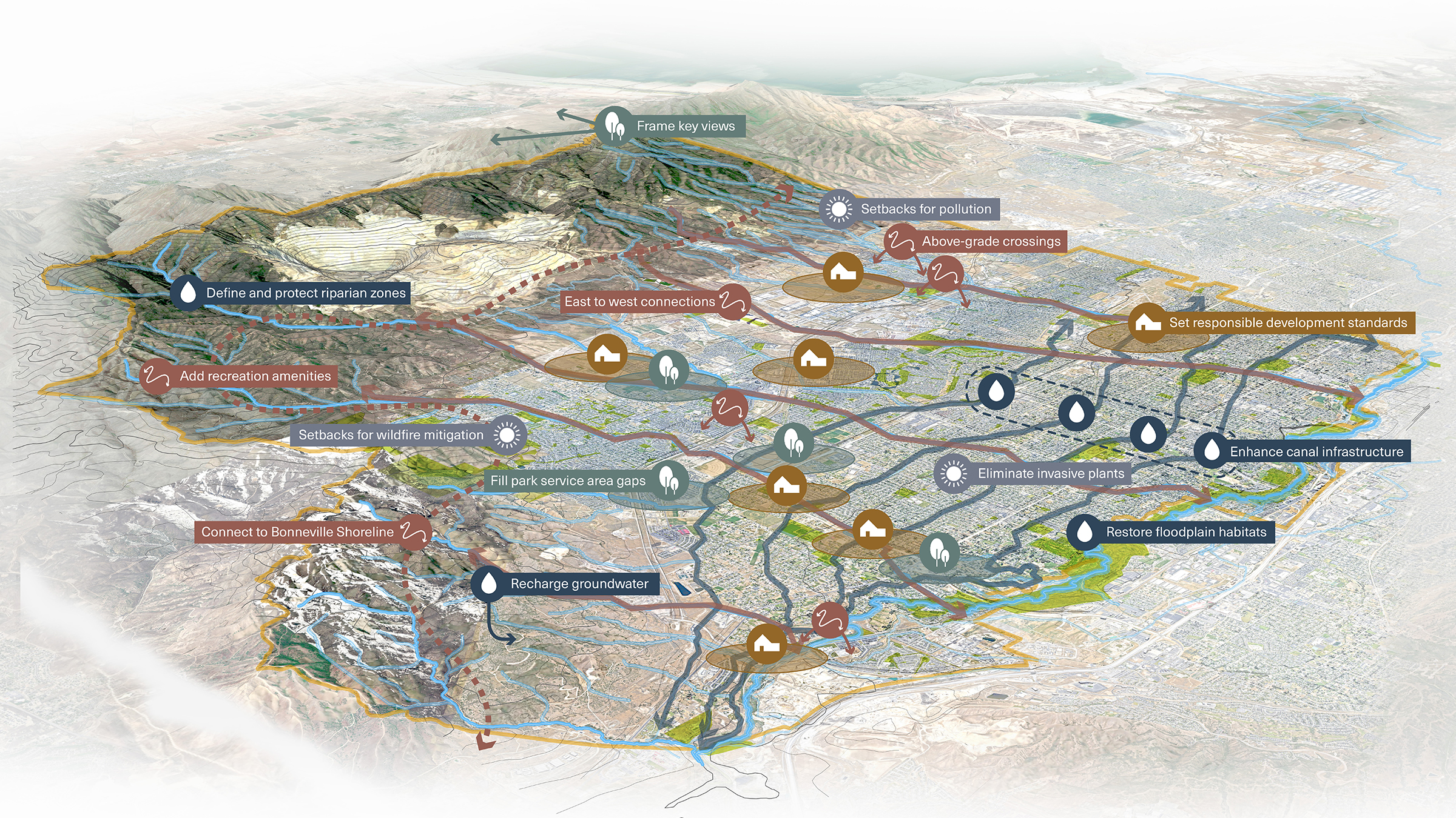
The H2Oquirrh Vision Plan addresses goals in hydrology, open space preservation, development, recreation, and sustainability.
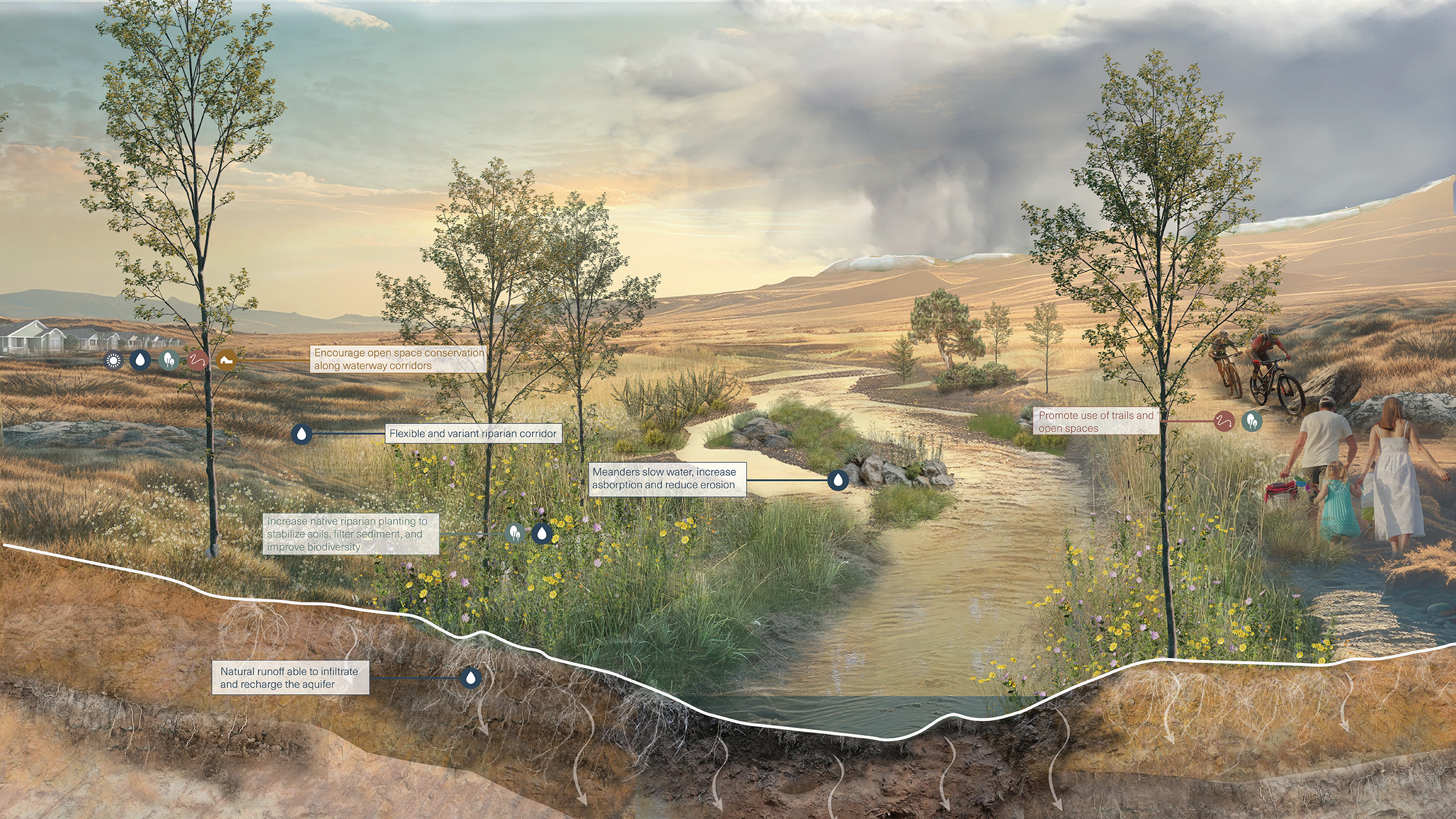
The naturalized upper watershed of the Oquirrh range enhances environmental and recreational value and maximizes groundwater recharge.
A Plan Rooted in the Water Cycle
Working together with LimnoTech’s environmental engineers, the team realized the priority was not to put more water in the creeks, but to send it underground. When rain and snowmelt soak into the ground, that water is stored in the aquifer and slowly released back into streams and rivers that flow to the Great Salt Lake. When land is paved, the water runs off quickly and is often lost to evaporation or contaminated by pollutants. The H2Oquirrh Vision Plan focuses on keeping water in the ground longer, helping sustain the flows that reach the Great Salt Lake over time, while giving cities practical guidance for coordinating development, infrastructure, and open space.
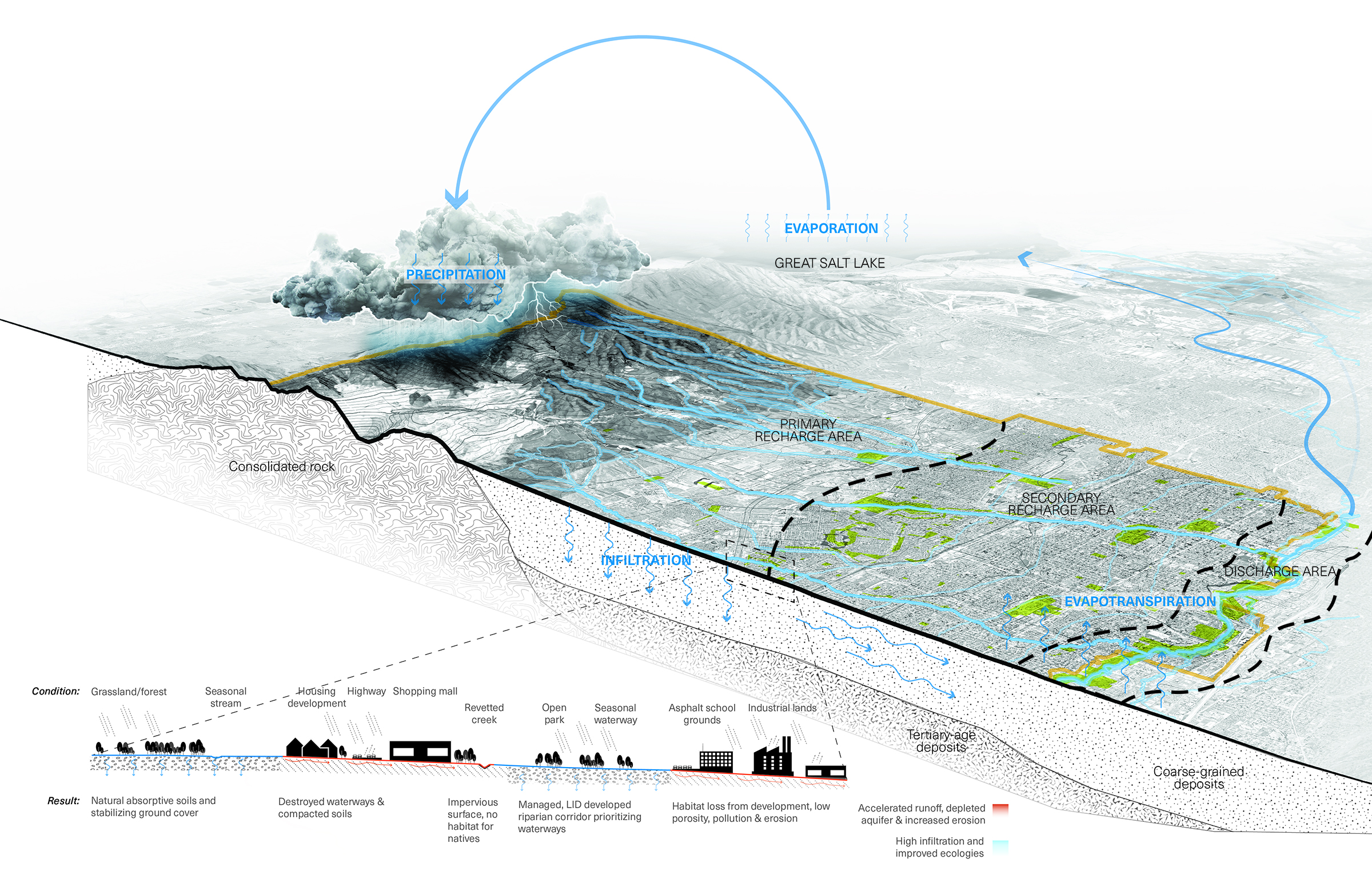
The plan prioritizes strategies that increase groundwater recharge as a long-term strategy to improve the health of the Great Salt Lake.
Protecting Natural Systems First
When waterways are allowed to function naturally, they help manage flooding, cool surrounding areas, and support native plants and wildlife. The plan protects key recharge areas and connects open spaces along the creeks to give these systems room to work. By setting these priorities early, H2Oquirrh helps communities make consistent decisions about where to build and where to preserve land, as well as how to do so with a water-first mindset.
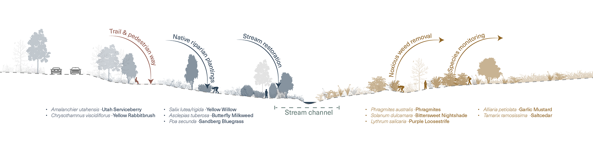
Revitalizing riparian corridors relies heavily on restoring natural ecology along the waterways.
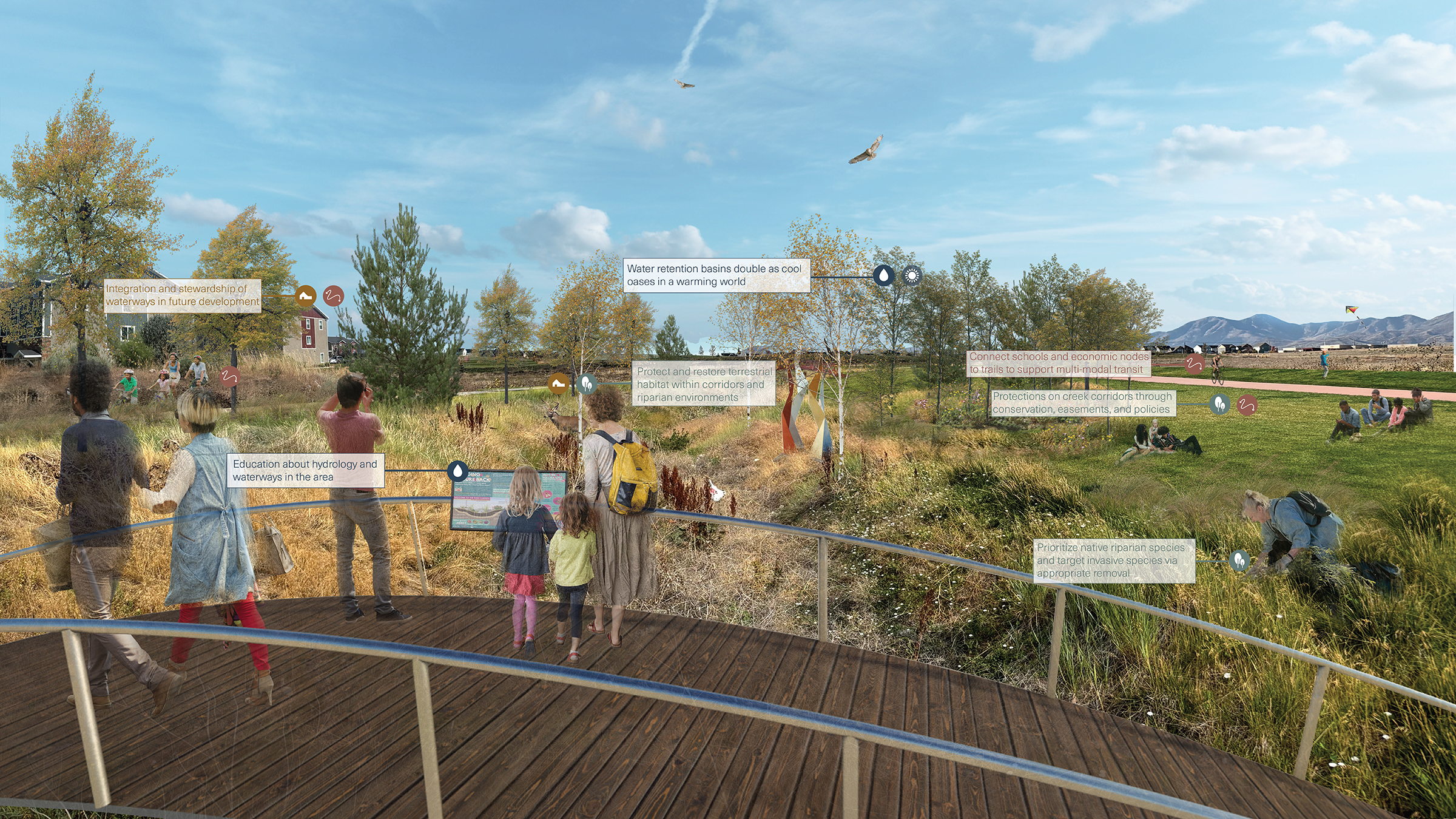
Intentional interaction between people and the environment builds awareness for the waterways and maximizes the value of riparian buffers.
Connecting People, Communities, and Decisions
The H2Oquirrh Vision Plan guides how cities make decisions near the waterways. It identifies where trails and public access make sense, and where land should remain open to preserve natural ecosystem services and support groundwater recharge. It also gives clear direction for future growth, encouraging development to engage the creeks as visible, shared community features. The plan was developed through collaboration among six cities, Salt Lake County, Wasatch Front Regional Council, and other regional partners, creating a shared approach that communities are already using to guide land use decisions and pursue funding.
Additional References
LimnoTech: H2Oquirrh - Southwest Waterways Visioning Plan
H2Oquirrh Storymap
KUER: Salt Lake County wants a plan for the Oquirrh’s waterways as development moves in
2023 Watershed Symposium: H2Oquirrh Vision Plan for Waterways of Southwest Salt Lake County
2024 Watershed Symposium: H2Oquirrh - A Vision for Salt Lake County’s Southwest Waterways